
You are here: RAPID » ABC Home » Science background » The Atlantic conveyor belt

Figure 1. Sea surface temperature and surface circulation. MORE

Figure 2. The global ocean 'conveyor belt'. MORE

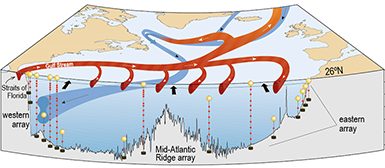
Figure 4. The global ocean 'conveyor belt'. MORE
The Atlantic conveyor belt
The ocean plays a major role in regulating weather and climate. Ocean currents transport heat from the tropics to high latitudes and moderate global warming by removing carbon dioxide from the atmosphere. Central to both is the global ocean circulation - a 'conveyor belt' of surface and deep currents, powered by two different 'engines'.
The global ocean circulation
Flow in the surface ocean is driven mainly by the prevailing winds - hence the name, 'wind-driven surface circulation'. The surface circulation consists of several large gyres - 5 in the subtropics, and 2 in the Northern Hemisphere subpolar regions (figure 1).
Vertical water movement is driven by seawater density - a function of temperature and salinity; so this part of the ocean circulation is known as the thermohaline circulation (THC) referring to temperature (~thermo) and salinity (~haline). Cold, salty water sinks in the Southern Ocean and subpolar North Atlantic and flows through the deep ocean basins (figure 2), only returning to the surface through mixing and upwelling after hundreds of years.
The Atlantic meridional overturning circulation (AMOC)
The Southern Ocean and the North Atlantic are the only regions where seawater can leave the surface and sink into the deep ocean. The southern ocean has a number of regions where deep water forms in this way - usually related to the formation of sea ice in the regions surrounding Antarctica. In the North Atlantic deepwater formation is linked to the gradual cooling of high-salinity Atlantic water that flows northwards from the subtropics in currents that are continuations of the Gulf Stream (figure 3).
If the formation of North Atlantic deep water were to suddenly slow down or stop, this would reduce the northward flow of warm water to the high-latitudes, with serious implications for North America's east coast and western European climate. The RAPID programme was started in 2004 to assess the possibility of the THC suddenly collapsing, and to establish if it would be possible to get early warning of a collapse by observing vertical ocean circulation in the Atlantic.
It is not possible to measure the THC directly. Instead we measure the Meridional Overturning Circulation (MOC) - poleward flow of water in the surface ocean and the return flow in deep ocean currents. The Atlantic MOC (AMOC) is measured at 26°N by the RAPID array - a series of moorings crossing the ocean basin from Florida to Morocco. (figure 4).
The RAPID observations show that the AMOC varies far more at seasonal and interannual time scales that we originally thought. We now know far more about AMOC variability and how this may be linked to seasonal and interannual variations in climate.
Will the AMOC collapse as a result of global warming?
Answering this question is not necessarily straightforward. Early, simple climate models predicted an abrupt collapse of the THC caused by freshening North Atlantic water. Newer climate models do not show this effect. However, most IPCC type climate models do predict a slow-down over the 21st century.
Even if an actual AMOC collapse now seems unlikely, there is still a need to understand how changes in the AMOC is linked to climate variability and change. For example, ocean transport of heat and freshwater are related to the strength of the MOC. This makes it possible to use the RAPID measurements to help us understanding the links between variability and change in the AMOC, and climate impacts such as changes in the Atlantic storm tracks and interannual variations in winter temperatures. Since warm water expands, there is also a need for more information about links between sea level rise, and changes in the heat content of deep water both in the Atlantic and elsewhere.
There is also a likely link between changes in the AMOC and variability and change in the ocean's uptake and storage of atmospheric carbon dioxide. Developing a more detailed understanding of the AMOC's role in the global carbon cycle is a key aim of the ABC Fluxes project, a RAPID project that started in 2014.
UNDER DEVELOPMENT
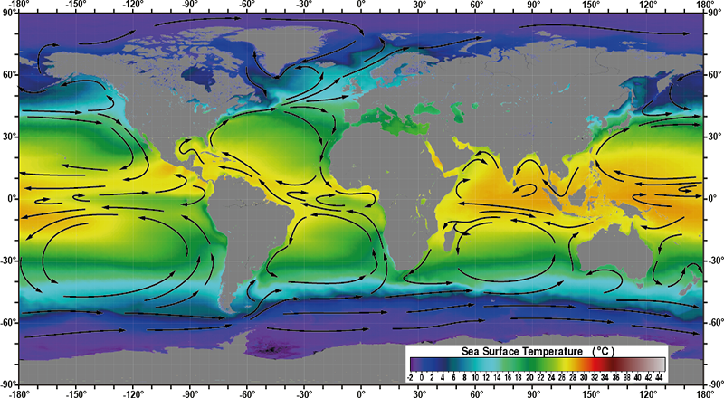
Mean Annual Sea Surface Temperature (SST) from NASA MODIS, with arrows indicating the surface circulation.
The wind driven surface currents form large subtropical gyres, north and south of the equator in the Atlantic and Pacific, and in the South Indian Ocean.
In the North Indian Ocean there is no permanent gyre. Instead the reversible monsoon winds create a gyre-like circulation during northern hemisphere summer,
which slows down or disappears during the winter monsoon. In the North Pacific and North Atlantic the currents also form two smaller subpolar gyres at around 50-60°N.
On the western side of each subtropical gyre fast and narrow western boundary currents carry warm water from the tropics to mid latitudes. On the eastern side broad and slow eastern boundary currents return cool water towards the tropics.
In the Atlantic warm surface water from the western boundary current reaches further north than in the Pacific. The relatively warm, salty water of the Gulf Stream system remains at the ocean surface west of Svalbard to a latitude of about 80°N before it dips underneath the colder, but much fresher polar water. The heat released by this warm water makes the climate in regions bordering the eastern North Atlantic warmer than at similar latitudes elsewhere.
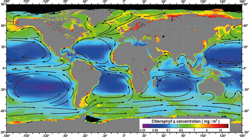
Mean Annual concentration of phytoplankton chlorophyll from NASA MODIS, with arrows indicating the surface circulation.
Phytoplankton productivity is closely related to the flow of ocean currents.
At mid and high latitude winter mixing of surface and deep water returns plant nutrients to the sunlit surface layer,
making mid and high latitude more productive than the subtropical gyres, where a permanent thermocline prevents
mixing between surface and deep water.
Plant productivity is higher along the equator, where the currents diverge and create an upwelling of deeper water. Along the eastern boundary of the subtropical gyres the prevailing winds drive surface water away from land, giving rise to coastal upwelling of nutrient-rich deep water. The ecosystems of these coastal upwelling regions are the most productive in the world.
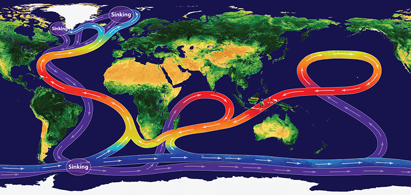
The global ocean 'conveyor belt'. Credit: NOC/V.Byfield. PDF version available on request
The global ocean 'conveyor belt' received its name because of the way ocean currents transport heat, salt, nutrients, dissolved gases, and much else around the global ocean.
It links surface and deep currents through cooling and sinking of surface water in the North Atlantic and the Southern Ocean. Deep water returns to the surface ocean through mixing and upwelling,
but this may take hundreds of years.
The Southern Ocean (around Antarctica) links the Atlantic, Indian and Pacific Ocean. At the surface warm surface water flows from the Pacific to the Indian Ocean through Indonesia, and from the Indian Ocean into the Atlantic as 'Agulhas rings'. Agulhas rings are eddies of warm water breaking off from the warm southward-flowing Agulhas Current where it meets the Antarctic Circumpolar Current and is forced to flow eastward in the 'Agulhas Retroflection'.
NOTE: This is a schematic representation of the global circulation of deep and surface currents, not a current map. Map of the main ocean currents with names.
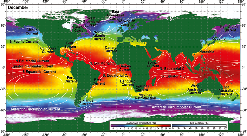
December sea surface temperature with the main ocean currents.
Credit: NOC/V.Byfield. PDF version available on request